Wednesday, May 2, 2012

Day 17 - Greenhead to Twice Brewed

Today's Greenhead to Twice Brewed section hardly felt like walking at all after yesterday's 22 mile bogfest marathon. However this is a good section of the Pennine Way to split rather than walking through to Bellngham as it's the Hadrian's Wall section, which means lots of fantastic views and sights which deserve more than a cursory glance.

Since our walking guide gave today's mileage as just 7 miles there was no hurry to leave last night's Greenhead Hotel (which was excellent), no hurry with the walking, no skimping on the photography, no holding back on striking up conversations with fellow walkers, and no avoiding diversions to sights off the Pennine Way. To start with this meant heading out west from Greenhead to join the Pennine Way where we left it, rather than heading north for the closest connection. The point where we rejoined the Pennine Way is where it crosses the A69, probably the busiest road that the path crosses (the M62 crossing in week 1 was a footbridge, so that's cheating). This is the sort of footpath <--> busy road crossing of which there are many on the A30 in Cornwall, where I've never seen any walkers, and always wondered if they're really used as they look so risky. Certainly this one must be well used as it's unavoidable for walkers who don't stop in Greenhead.

A69 - Pennine Way Crossing
After skirting around the perimeter of Haltwhistle Golf Club the path crosses the Newcastle to Carlisle railway at an unattended crossing. I like these crossings. Who really gets killed on this sort of crossing apart from people who are suicidal or playing dare ?
Newcastle to Carlisle railway
Almost immediately the path reaches Thirlwall Castle, a 12th century castle of which there's not much more than a couple of walls left. From paintings and drawings in the mid 18th century it was still in a pretty good state then, but the theft of stone, damage due to felling of trees nearby, and general weathering quickly reduced it to a shell. Apparently there's a local legend that during one raid by the Scots a family servant jumped down a well to hide the family's treasure, and he's still down there. The most valuable item he took was a gold table. Sounds a bit Saddam.

Thirlwall Castle

A brisk ascent east away from Thirlwall Castle and past the Roman Army Museum carpark, and we were onto our first real section of Hadrian's Wall. This is one of the most picturesque sections of the wall, and less walked than parts further east. At times the wall completely disappears and its path has to be inferred from the line of the cliffs or shallow ridge of stones. At other times the wall is at its full 6' thickness with frequent turrets or milecastles, where soldiers would be stationed to keep watch over their section of the wall. Largely the wall was used as a means of controlling trade between the sides rather than to prevent invasion by tribes to the north. Low dips in the wall would be crossing points where goods crossing either way might be subject to taxies or duties.
Hadrian's Wall - turret 44B
A couple of miles east, at Cawfield Crags, we got into conversation with a Canadian couple, Daryl and Dina, from British Columbia in Canada. They have been over in the UK and Ireland for almost 6 weeks, visiting historic sites which have a relevance to their family histories. After explaining that I'm raising money for the MND Association they immediately fished out £5 to give me as sponsorship. What nice people. I'll definitely try to visit them when I'm next visiting my mother's sisters in BC. Let's see if they remember any of this.

Nothing could be finer than to talk to Daryl and Dina in the morning
Another couple of miles east at Winshield Crags the wall is again at its photogenic best, but we're perilously close to the end of today's section of the Pennine Way at the Steel Rigg car park, where we head down to Twice Brewed.
Hadrian's Wall at Winshield Crags
This seems a bit ridiculous. We're at the end of today's walk by 2:15pm, so rather too early to be checking into the hotel and twiddling our thumbs for the afternoon. However, we're only a couple of miles from Vindolanda, one of the best museums and excavation sites on the wall. I managed to pick out a footpath on the GPS which will take us to Vindolanda avoiding the main road, and we were there by 3pm, so plenty of time for a late lunch and for a thorough visit.

Vindolanda has a long history of excavation, including by the Rev. Anthony Hedley who was probably the first historian and archaeologist to revive interest in Hadrian's Wall back in the early 1800s. He built a house on the site, and this remains to this day as the main part of the museum (/cafe/gift shop), and with wonderful landscaped gardens including recreations of Roman temples, homes, and shops.

Rev Headley gardens

The museum alone is worth the admission price, housing a significant collection of artifacts found at Vindolanda, including the largest collection of leather of any Roman site in the UK, and the famous Vindolanda Tablets. This is a large collection of wooden tablets bearing inscriptions of various sorts, mainly military operational matters, along with many letters from ordinary Roman soldiers stationed along the wall. Most of the tablets are now at the British Museum in London, although several are now on return loan at Vindolanda.

The artifacts on display are also remarkable; many well preserved examples or footwear, military items, working tools, ceramics, and painted glassware, as well as many perfectly preserved stone carvings of various types, religious, ceremonial, and domestic.


Tombstone of a wealthy woman

Why isn't he happier ?
Vindolanda is currently under active excavation, and when we arrived there were many archaeologists and volunteers at work outside, excavating some near areas of the camp. It's interesting to see what sort of state the Roman remains are found in in their 'raw' state, in this case a few lines of clear wall stones, a few troughs forming a gutter, and a lot of loose rubble. At some point these will presumably be "consolidated" into a form which the archaeologists believe to be a true representation of how the buildings were 1800 years ago, although quite how that is interpreted is something of a mystery to me.
Vindolanda - 2012 excavations

After leaving Vindolanda we headed back to the Twice Brewed Inn, where we're staying tonight. The pub and food are pretty good (6 real ales on tap), but the hotel is a bit of a wreck. I was given a single room over the kitchen, which is noisy, and was told that there were no better rooms, and even if there were I would be surcharged to move to another room. Many other complaints about the rooms (no TV, peeling paint etc) and shared shower rooms (uncontrollable scalding hot shower with blocked nozzles), but that would be petty. Oh, too late.

Milage total: 12.8 miles, including the Vindoland excursion.

Final Sean update: he finished today, and is now in Kirk Yetholm. He'd always planned to finish the walk in 16 days, and stuck to it, assisted by walking Cross Fell on a good weather day (when we were a day behind on High Cup) and merging a few shorter days together which we've kept separate (like today). His final day was the Byrness to Kirk Yetholm section, all 27 miles or it, starting at 6am this morning in the mist and cloud. Saffie was so tired that when he paused to change maps he found her curled up asleep at his feet.


By 4pm he still had another 9 miles to go, and was exhausted and limping. A mile from the end a farmer took pity on him and gave them a lift to the finish line.


If you would like to donate to the MND Association, please visit http://www.justgiving.com/PhilipJAWhite

Tuesday, May 1, 2012

Day 16 - Garigill to Greenhead

Groan. That was a long day. Since we had needed a second go at Cross Fell yesterday we had to combine two days' walking into one in order to keep up with the timetable. The guide book says Garigill to Slaggyford is 10 miles, and Slaggyford is 11 miles, and that seems to be about right. With a couple of minor diversions from the route the GPS measured it as 22 miles, but it was much more tiring than we'd thought it would be from the maps, which make it look largely like a combination of riverside paths and some moorland. In practice the riverside paths were slippery, the path often diverted uphill across a field then dropped back again through the next field for no obvious reason, and the moorland sections were mostly very wet and boggy with no path markers. All in all this wasn't a very exciting walking day with no real high points, and the second half, after Slaggyford, is less interesting than the first. At least the rain held off for the day, and the strange cloud formations coming off Cross Fell made for interesting skies.

The Pennine Way section just north of Garigill is pretty enough, but not really as exciting as the upper Tees riverside walks that took in Low and High Fell, or the Cauldron Snout section. Leaving Garigill the path follows the River South Tyne, heading north. It's a fast flowing, shallow, small river, lined with trees most of the way. I imagine this is a salmon or trout fishing river in some of the slower, deeper sections, although I didn't see any angling club signs anywhere.

South Tyne near Garigill

It's nice to see a variety of plants here . Lots of ramsons (wild garlic) which are at least a month behind those in Cornwall, not even having any flower buds yet. I thought that the below flower was Coltsfoot, although now I'm not sure.
Thank you to Philippa - Butterbur it is ! There were no leaves present, just the flower spikes.

Butterbur by the South Tyne


Only a mile or two up the river from Garigill we saw our first red squirrel, something that neither of us had ever seen in the wild, so something of a thrill. Unfortunately it hopped up a tree and disappeared before there was any chance of taking a picture. It looks like this is a red-only zone, since there were anti-grey posters attached to footpath signs all along the river.

Red or Dead

As I mentioned before we had some spectacular cloud action going on today. I don't know whether this is the result of the Helm Wind (the only named wind in the British Isles) coming off Cross Fell, but certainly it seemed to be coming from that direction. Much of the day it appeared as if there was some enormous mountain range behind the cloud.

Foothills of the pretend Andes

Just 4 miles out of Garigill we reached Alston, not quite a thriving metropolis, but large enough to have a cash machine and an outdoors shop (owned by cousin of last night's taxi driver) where Jonathan could get some replacement gaiters. The mysterious cloud formations again provided a wonderful backdrop.

Alston . Yes, the sky really did look like that.

A couple of miles north of Alston the Pennine Way skirts around Whitley Castle, a Roman Fort lying about 20 miles south of Hadrian's Wall, and as yet almost unexcavated. The area occupied by this fort looks quite substantial, and I can imagine that in years to come it might well be added to the Hadrian's Wall tourist trail if excavations unearth any substantial artefacts.

Whitley Castle

I wish I could identify more breeds of sheep, as now we're seeing quite a variety. Must try to memorise what I'm looking at in the sheep judging tent at the Royal Cornwall Show next year.

Not so horny anymore

After a couple more muddy miles mostly along the South Tyne banks the Pennine Way reaches Slaggyford, a small village notable for a) A very ugly static caravan by the river. Painting caravans green does not make them blend in, and b) A large percentage of houses having "for sale" signs. I wonder if there's some connection between a) and b). Slaggyford is where we would have ended today's walk if we hadn't decided to combine today's & tomorrow's walks. Since we there by 1pm that would have been a very short day.

Near a large well-tended house at Burnstones, which looked like a hunting lodge, the barbed wire fence sported 5 dried out mole carcases. I remember my father pointing hanging moles out to me many years ago, and it seems to be a northern thing (I've never seen this done in Cornwall). I think the principle is that since moles have a keen sense of smell it deters other would-be invaders if they smell the decaying corpses of other moles. Seems unlikely though since the wind would have to be blowing in the right direction.

Pour encourager les autres

North of Slaggyford the walking deteriorates, and much of this section of the walk is boggy moorland, not quite as bad as Sleightholme Moor in the current drier weather, but still hard work to negotiate. Particularly at the northern end of this section, on Blenkinsopp Common, the land seems very degraded. I know that this is Open Access, wild moorland, but the lack of variety of plant species is notable. Other than sphagnum moss, and tussocky grass, there's really very little. Surprising that there's no heathers, ferns, orchids, or any of the other plants that we saw last week. Here's a typical view across the featureless Blenkinsopp Common.

Move along please, nothing to see here

Something I haven't commented on previously is that on the Pennine Way the two most common path markers are either the official wooden fingerposts or just "PW" carved or scrawled on any stone or piece of wood that's to hand. I must put together a collection of "PW" marker pictures in a later posting, as they're often quite imaginative.
PW not RIP
Eventually the Pennine Way comes off Blenkinsopp Common and heads eastwards toward Greenhead, which is where we are tonight, in the Greenhead Hotel. It's been a long tiring day and we'll be glad of tomorrow's mere 7 miles, albeit on the roller coaster of Hadrian's Wall.


If you would like to donate to the MND Association, please visit http://www.justgiving.com/PhilipJAWhite

Monday, April 30, 2012

Day 15 - Garigill to Dufton

Updated : fixed the broken pictures which were caused by the extremely dodgy Wifi in Garigill.

As the song says, What a difference a day makes. Although the weather forecast had changed overnight from pretty much "all sunshine" to "might be a bit of sun if you're lucky" that was more than enough. Combined with the drop in wind speed from somewhere around 40mph to 20mph that was enough to allow the plan outlined yesterday to work. The gist of the plan is that we would walk the Dufton to Garigill section of the Pennine Way in reverse, since we were staying in Garigill last night, so we didn't need to miss out anything of the official Pennine Way.

This section of the Pennine Way is a special one, taking in Cross Fell, the highest peak of the Pennine Way, and the highest point anywhere in England outside of the Lake District. Cross Fell is one of a set of 3 high peaks, the others being Great Dun Fell and Green Fell, making this the "largest block of high ground in England", whatever that means, according to Wikipedia.

Approaching Cross Fell from the Garigill side isn't really very exciting, with a gravel and rock track taking up most of the distance, climbing slowly for about 600m (2000 feet) over 5 miles. That was OK though, since today's weather forecast was predicting fog until early in the afternoon, so there was no real prospect of views until we were near the peak, whichever way we approached it. That proved to be right, and most of the way up were were stuck in some sort hybrid fog/low cloud, and lucky to see more than 50m ahead.

Cross Fell ascent
At about 700m snow reappeared, the first time we've seen any for a few days.

Cross Fell snow
The track continues up to the Cross Fell bothy, known as Greg's Hut (after local walker John Gregory) which is looked after by the Mountain Bothy Association. Judging from the remnants of food & fires, and from the visitor's book this bothy is well used, which isn't surprising given this fell's reputation. If it can be as inhospitable as it was yesterday then it must be deadly during the winter months.

Greg's Hut - don't ask for a hot pasty

Inside looks a bit Tibetan with the flags


Soon after this the path heads off left (south) towards the peak of Cross Fell, about 200m higher. Almost immediately it becomes impossible to spot where the path is, sometimes it's a stream, sometimes it's a field of rocks, and sometimes there are a few flagstones. In weather like today's, when visibility was no more than 50m at the best of times, it would be hard to imagine navigating this without a GPS.

Eventually we reached the summit of Cross Fell, the ultimate peak of the Pennine Way, so here goes with the spectacular views... Of course we didn't expect anything today, given the low cloud we were walking in, so weren't disappointed. At the summit there's the expected trig point and one of the 4-way loose stone shelter seats that we saw on Shunner Fell.

Cross Fell - brought to you by Mars

Since we're doing this section in reverse the next peak to be reached was Great Dun Fell (848m), a couple of miles south. Great Dun Fell has a radar tracking station on the top, part of the air traffic control system, although it looks rather military. The path between each of the peaks was again very difficult to find today, being shrouded in cloud much of the time. The radar station shown below was one minute in brilliant sunshine and the next completely hidden in the cloud.

Great Dun Fell  radar station
The final fell of the three big ones is Green Fell, which was even more difficult to locate today. There's really not much to see here, just a wide grassy plateau with some large stone piles, although the final pile is a huge obelisk shaped mass, so that's worth seeing (in the distance below).

Green Fell - two of its many cairns


After Green Fell we started the descent to Dufton, which was by now being revealed in brilliant sunshine down in the Eden valley. This part of the walk became a real pleasure once the sun finally came out at about 3pm. The grass and stones were dry from the still fresh breeze, and we had magnificent views in all directions apart from back up to the peaks. Briefly the clouds parted, giving us a view back up to Cross Fell.
View back to Cross Fell

I thought it might be worth sitting in the same spot which was yesterday's limit, and taking the same picture of Knock Fell through "those two cairns". Looks rather different today.

Knock Fell in the sun

About an hour later and we were back in Dufton, which is becoming very familiar. Jonathan went back to yesterday's B&B to reclaim a book he'd left there, and I headed to the Stag Inn to wait. Unfortunately the pub doesn't open until 6pm on weekdays, so I ended up just waiting outside in the sun, but what a lovely novelty.

I had phoned Discovery Travel this morning to explain our new plans to them. Since the original plan required taxi to&from Slaggyford I negotiated a trade-in for a single journey back from Dufton. That was a good deal since this would otherwise have been an £50 taxi fare.

So, back in Garigill now, having had another good stodgy meal at the George & Dragon. Tomorrow's another long day, 21 miles onto Greenhead. Another county and our first contact with Hadrian's Wall.

If you would like to donate to the MND Association, please visit http://www.justgiving.com/PhilipJAWhite

Sunday, April 29, 2012

Day 14 - Dufton to Hades

As I mentioned in yesterday's post the weather forecast was predicting heavy rain for today. What became clearer as the evening wore on was that it was getting very windy indeed, and by Sunday morning the weather forecast was issuing gale warnings for the Pennines, with gusts of 50-60 miles an hour expected. Since we've been told that wind speed up on the peaks is often much higher than in the valley it was a rather scary prospect.

Only slightly daunted by the forecast, and after a lecture on hill-walking safety from our miserable landlady, and after reading the newspaper clipping pinned to the wall about a walker blown to his death on Helvelyn, we set off anyway. The plan was that we'd keep climbing as high as felt safe, and if we got to the first of the peaks, Green Fell, and felt in danger then we'd take the emergency path down the east side of the fells, which the landlady had told us about.

Even the first mile or two out of Dufton didn't feel very safe. There were branches down everywhere, and several trees wrenched out with their roots had fallen over the path. Maybe these were weaker or diseased specimens which had come down overnight, but despite the relative shelter that the trees provided I was rather glad to eventually be away from the tree line so we would avoid being injured or killed by something crashing down.

Tree down on Hurning Lane
Large ash tree branch snapped off
As we passed through the farms on the way uphill there were loose coils of wire blowing around a farm yard, creaking and crashing doors and gates, and torn plastic sheeting flying horizontally in the trees. It felt rather like the opening credits from a horror film.

The gale was blowing from the north-east, which not only meant that it was very cold (from Scandinavia) but also that we were heading directly into it, hugely increasing the effort of the uphill walk. A gradient of only 30° felt more like 45°, and 45° more like 60°. In addition, every so often there would be an even stronger gust which would knock you off your stride, or force you to brace with both feet to avoid being blown over altogether. Sitting down to recover for a couple of minutes, I thought I should take at least one photograph before the predicted heavy rain set in for the afternoon.

Knock Pike

After crossing Swindale Beck we met an American woman with a large rucksack coming down the hill. She looked rather shell-shocked, and said that she had been blown off her feet once too often, so was abandoning plans to go up to Green Fell. She had only got as far as the first couple of cairns on the first ridge before turning around.

Half an hour later we saw the 5 men who had been walking the same Pennine Way section as us yesterday. They too had given up when they reached the first cairns, and were returning to Dufton. At that point we realised that it was likely to be suicidal to attempt to climb to Green Fell, let alone Cross Fell, which is the highest point of the Pennine Way. Since "those first two cairns" were the day's unofficial highest reachable point we agreed to at least go up there, then head back down. On the final approach to the cairns we were actually down on hands and knees a couple of times to avoid being blown over.

View from "those first two cairns" to Knock Fell

As it turned out from the GPS trace of today's route, we had climbed from the B&B at 160m to the cairns at 520m, so an ascent of 360m (1180 feet), and a total distance for the day of 6.5 miles. Quite an effort for no real satisfaction, apart from still being alive.

So we returned to the Stag Inn at Dufton, and downed hot coffee (the stuff at breakfast this morning looked like weak Jasmine tea) to warm up, before catching a taxi onto tonight's B&B at Garigill, where we are now.

So here's the plan:

  1. Tomorrow's weather forecast is completely different from today's, predicting sunshine and lighter winds for the whole day. Assuming that proves to be correct in the morning then we will walk today's section of the Pennine Way, except in reverse (east->west) so we aren't delayed in the morning (it takes about an hour to get back to Dufton by road). Then we'll again get a taxi from Dufton back here, since we're staying at this B&B in Garigill for two nights anyway.
  2. Then on Tuesday, when we're meant to be walking to Slaggyford, just 10 miles up the river from here, we'll instead walk onto the next B&B at Greenhead. That will make for a 21 mile day, but it's all fairly gentle valley walking so I think that's possible. After all, we've already walked 17 or 18 miles a few times, and those included some ascents.
Update on Eric: Rather unexpectedly, Eric, who started the Pennine Way on the same day as us, is staying at the same B&B as us in Garigill. Brigantes had booked him in here for 3 nights, with transfers back to Dufton, and back from Slaggyford, on the days either side of the walk here. However, it seems that he twisted his ankle on the horrendous walk from Keld, and hasn't been able to walk much since, which explains why he got a lift from Baldersdale. He's walked a few miles each day since, but decided that it's too painful for him to be able to walk the remainder of the Pennine Way, so he's going back home tomorrow. That's a pity, but he has walked over 170 miles so far, so all credit to him.

If you would like to donate to the MND Association, please visit http://www.justgiving.com/PhilipJAWhite

Saturday, April 28, 2012

Day 13 - Langdon Beck to Dufton

The day didn't start too promisingly. The weather forecast was predicting that any early showers would clear away and the sun would be shining by 9am, but as I read that forecast then looked out of the window it was snowing. False alarm; the snow and drizzle was clear by 10am, and this turned out to be an even better day for weather than yesterday.

From Langdon Beck to Dufton the Pennine Way again follows the River Tees valley, but gone are the gentle leafy pastures we passed through yesterday. Now the river is faster flowing but shallower as it passes through the steep sided valleys upstream. Strangely this section of the Pennine Way heads south-west, so at the end of the day we were actually further south than when we started. I suppose this so that the next high peak, Cross Fell, can be included in the Pennine Way, as well as the very picturesque River Tees sections.

The walking guides warn that in several places today the path along the Tees disappears amongst the boulders that have fallen down the north side of the valley. Slow going even on a dry day like today, but this must be a treacherous path after rain.

Upper Tees near Merrygill
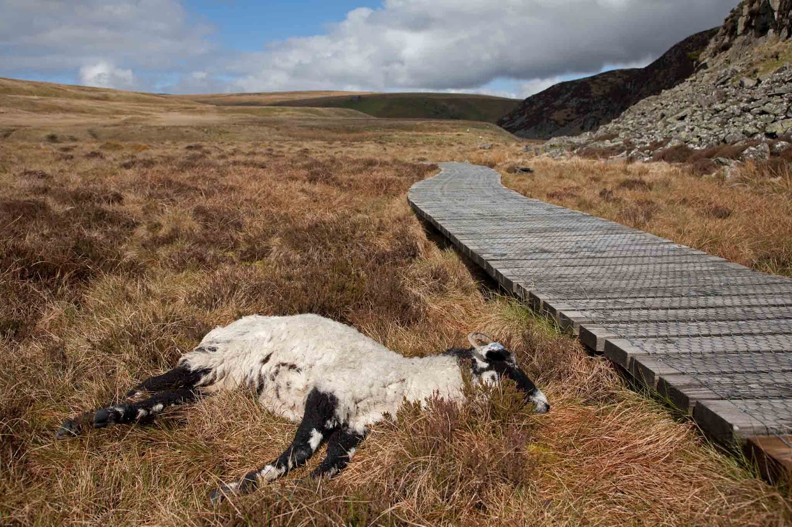
Yet more Juniper along the banks of the river here, especially on the south side of the valley, and profusely covering an island in the river where presumably no sheep can nibble the low-growing bushes in the hard winter when little else is available. Where the path briefly diverges from the river at Lingy Holm a sheep lay dead by the path, apparently uninjured, and not obviously in lamb. It can't have been dead long as the eyes were still intact. Unfortunately we were at least a couple of miles from the nearest farm so reporting the animal wouldn't have been easy. I wonder if the farmer would do anything with the body anyway, unless it had died of something infectious.

Dead sheep at Lingy Holm

Half a mile further upstream is the famous Cauldron Snout waterfall, another spectacular cascade today after the past few days' rain. I rather prefer High Force myself, but it's nice to have a choice of 3 different shapes of waterfalls within so short a distance.

Cauldron Snout

Above Cauldron Snout is the Cow Green Reservoir which was built in the 1960s to supply the water requirements of Teesmouth. Interestingly water isn't pumped from the reservoir; instead it is simply used to regulate the level of the Tees so that water can always be extracted downstream. Seems like a good idea, as it means that the wildlife that depend on the river also get the benefit.

Cow Green Dam

After Cow Green Reservoir the Pennine Way now separates from the river for several miles, and the Warcop military training area covers much of the area south of here. Today red flags were flying over the warning signs, so maybe there were training exercises taking place somewhere, although we didn't see or hear anything. All the way from Cow Green the path is slowly ascending at a gentle gradient so that eventually we were at about 580m. Since there was a cold easterly wind today the sun had little effect on the temperature, and as we headed higher we were walking in three layers and gloves for much of the time. Managed to find a convenient shake hole for lunch, and suddenly it was warm again.

Shake hole lunch

Just west of the lunching hole we reached High Cup Nick, undoubtedly the high point of the day, and possibly of the whole walk so far.  Spectacular views down his deep and wide glacial valley, with steep cliffs and rock pillars on both sides. There was a real satisfaction in reaching this vantage point, since there is really no other way to get here.

High Cup Nick panorama

For another mile or two the path follows high up along the north edge of the valley, and we were looking down from high on tortuous stone walls built along the stream at the valley bottom, and spotting isolated sheep that had ventured high up on the opposite side. Eventually the path starts to descend towards the wide valley of the River Eden, where Dufton is the first town we reach, and tonight's stop.

Descent from Hugh Cup - barn at Hartwaite
Tomorrow will be the hardest day so far, with the path climbing nearly 800m in the first half of the day. The walking guide says that the average temperature over the year on the peaks here is just 4C, and that severe gales are common. Also the weather forecast for tomorrow says heavy rain. Wish us luck.


If you would like to donate to the MND Association, please visit http://www.justgiving.com/PhilipJAWhite

Friday, April 27, 2012

Day 12 - Baldersdale to Langdon Beck

From the ridiculous to the sublime, day 12 (Friday 26th April) had some of the best weather and best walking so far, almost cancelling out yesterday's horrors. The route today consisted of crossing north from Baldersdale past some of the Tees reservoirs, cutting across farmland to Middleton-in-Teesdale, then following alongside the river Tees up to tonight's stop.

Almost as soon as we had left last night's B&B in Baldersdale, on crossing the head of the Blackton Reservoir we met two local women out walking what looked to me like a small black whippet, so I had to stop and talk to them. It turned out to be a black whippet-bedlington cross, only 8 months old, but for a few minutes an acceptable substitute for one of my whippets back home. The whippet rejoiced in the unlikely name of Busty, but apparently Busty is the name of an old Durham colliery.

Busty the almost whippet
Since they insisted on taking our photograph in return, here's a rare one of Jonathan (relaxed and smiling) and me (twisted and grimacing) at the western end of Blackton Reservoir.

Jonathan and me at Blackton Reservoir
Heading north from Blackton Reservoir the footpath passes by Hannah's Meadow at Low Birk Hatt Farm. This is where sheep farmer Hannah Hauxwell lived for 50 years, becoming the subject of several television series and documentaries telling of her life as a solitary sheep farmer in a house without mains water or electricity. The farm and its fields are now a Site of Special Scientific Interest and a visitor's centre.

Heading north from here the path crosses Hunderthwaite Moor and Mickleton Moor, which today were similar to yesterday's boggy moorland, requiring hopping between tussocks of grass to cross, but only a mile or so further on we reached the head of Grassholme Reservoir and there moorland suddenly stops and grassy sheep and cattle farms take over.

Grassholme Reservoir
As with the reservoirs we had passed last week these reservoirs (Blackton, Hury, and Grassholme) were constructed in the late 1800s to supply water to the rapidly growing nearby cities, in this case to Middlesbrough and Teesside, where the steel and coal industries were leading to a rapid growth in population. A newspaper clipping in last night's B&B documented the lives of workers housed in temporary sheds during the reservoirs' construction, with each shed housing up to 20 men, and a single woman, usually a widow, acting as the head of household.

Here's a good example of the local farm building style, with this barn having only tiny slits for windows to guard against the harsh winter conditions that are frequent hereabouts.

Barn just north of Grassholme Farm
Now heading north-east from farm to farm the path crosses to Middleton-in-Teesdale, a well-heeled small market town, made more attractive by sunshine, making the possibility of eating lunchtime fish&chips outdoors a reality. The last chance of a cash machine for many days, I suspect, but sadly the only outdoor shop where I might have bought a more waterproof jacket was "closed due to illness".

Approach to Middleton
From Middleton-in-Teesdale the Pennine Way becomes a riverside trail following up beside the river Tees, more like an afternoon stroll than the strenuous hillwalking of a few days ago. Today's gory picture was taken in one of the fields along the Tees, showing a docked lamb's tail with the rubber band which farmers place around the tail to cut off the blood supply, and thereby the tail. Tails are docked to reduce the likelihood of fly infestations, since sheep's tails aren't the cleanest of places. It doesn't seem to be a universally performed procedure though, and I'd say that at least half of the adult sheep which we're seeing still have their cacky tails intact.

And no, I didn't keep it as a souvenir.
Docked lamb's tail.

This section of the Tees is well known for the Low Force and High Force waterfalls, which of course were today in spectacular form after the past few days rain. First we passed Low Force, where the Tees drops about 6 metres over a pair of waterfalls.
Low Force
About three miles further upstream is the more famous High Force, about four times the height of Low Force, although through a much narrower channel.
High Force

I didn't realise that this section of the Tees is famous for its juniper trees. In fact it's the largest population of juniper trees anywhere in Britain. They're everywhere, along the sides of the Pennine Way, overhanging the cliffs onto High Force, and extending for miles upstream of this. In this photograph a couple of miles upstream of High Force all of the visible trees are juniper, making it look rather exotic, like tea trees in New Zealand.

Juniper bushes at Bracken Rigg
Although the juniper berries are currently very immature and green they still smell very strongly if you crush them in your fingers, leaving a lingering smell of gin.
Immature juniper berries - upper Tees
The upper Tees is also home to numerous alpine plants which thrive in the damp, cool climate. We'd been told to look out for Spring Gentians, and sure enough here they were on the banks of the Tees where two tributaries merge near Forest-in-Teesdale.

Spring Gentians on the bank of the Tees
Today's mileage: 16.8.

Tonight's stop is at the Langdon Beck Hotel, which is over a mile from the Pennine Way, so quite a distance to retrace tomorrow morning. Having chatted to various people in the bar tonight we found that:

  • The hotel owner is from Truro (although hasn't been there for over 10 years).
  • One of the customers is from a village just outside of Whitley Bay.
  • The hotel owner is a huge Stanley Kubrick fan, and I think he and Jonathan are still in deep discussion  downstairs about various obsessive details of his films and biographies.

Sean's update: He's camping in Duffton tonight (our stop tomorrow) after a 21 mile day, but given today's good weather I think it's been a shot in the arm for him and Saffie. It looks like the jacket is becoming more Saffie's than his.
Saffie camping at Duffton
On the bank of the Tees I sat down and woofed

If you would like to donate to the MND Association, please visit http://www.justgiving.com/PhilipJAWhite